


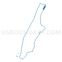
Voting District 7200067, New York County, New York
About
Outline

Summary
| Unique Area Identifier | 632371 |
| Name | Voting District 7200067 |
| County | New York County |
| State | New York |
| Area (square miles) | 0.27 |
| Land Area (square miles) | 0.17 |
| Water Area (square miles) | 0.10 |
| % of Land Area | 63.97 |
| % of Water Area | 36.03 |
| Latitude of the Internal Point | 40.86651110 |
| Longtitude of the Internal Point | -73.91526940 |
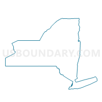
Maps

Graphs
Select a template below for downloading or customizing gragh for Voting District 7200067, New York County, New York


Neighbors
Neighoring Voting District (by Name) Neighboring Voting District on the Map
- Voting District 7100060, New York County, NY
- Voting District 7200048 7200049, New York County, NY
- Voting District 7200059, New York County, NY
- Voting District 7200060, New York County, NY
- Voting District 7200061, New York County, NY
- Voting District 7200062, New York County, NY
- Voting District 7200063, New York County, NY
- Voting District 7200066, New York County, NY
- Voting District 7200068 7200070-7200072, New York County, NY
- Voting District 7200073, New York County, NY
- Voting District 7800051, Bronx County, NY
Top 10 Neighboring County Subdivision (by Population) Neighboring County Subdivision on the Map
Top 10 Neighboring Place (by Population) Neighboring Place on the Map
Top 10 Neighboring Unified School District (by Population) Neighboring Unified School District on the Map
Top 10 Neighboring State Legislative District Lower Chamber (by Population) Neighboring State Legislative District Lower Chamber on the Map
- Assembly District 71, NY (122,886)
- Assembly District 78, NY (121,803)
- Assembly District 72, NY (117,394)
Top 10 Neighboring State Legislative District Upper Chamber (by Population) Neighboring State Legislative District Upper Chamber on the Map
Top 10 Neighboring 111th Congressional District (by Population) Neighboring 111th Congressional District on the Map
Top 10 Neighboring Census Tract (by Population) Neighboring Census Tract on the Map
- Census Tract 293, New York County, NY (9,033)
- Census Tract 309, New York County, NY (8,463)
- Census Tract 299, New York County, NY (3,834)
- Census Tract 269, Bronx County, NY (3,777)
- Census Tract 303, New York County, NY (3,753)
- Census Tract 307, New York County, NY (3,434)
- Census Tract 257, Bronx County, NY (1,912)
- Census Tract 297, New York County, NY (161)